The Kruger National Park was proclaimed on 31 May 1926 under the newly formed National Parks Board of Trustees, which became the controlling body of the park, and reported to the Minister of Lands. However, the proclamation, was made possible and preceded by much activity: The so-called Government Game Reserve 'Gouvernements Wildtuin' (in Afrikaans), was proclaimed by the South African Republic (SAR - more or less comprising current provinces of Limpopo, Mpumalanga, Gauteng and North West) on 26 March 1898. This game reserve comprised the area between the Sabie and Crocodile rivers. This was a tumultuous period in our History and less than a year later on 11 October 1899.
Kruger National Park is best known for its big game sightings and large expanses of wilderness; however, Kruger has a unique cultural and historical landscape and diversity, with well over 255 recorded archaeological sites ranging from early Stone Age (roughly 1 million years ago) to various Iron Age settlements and recent historical buildings and sites. (link provided in FURTHER READING). Many of these sites hold cultural and spiritual importance, while others reveal an exciting and romantic history of the area. Conservation of these sites is imperative due to their cultural and spiritual value and the historical importance. As national stewards of the conservation of the area we are legally bound to protect these sites. Sites that are currently open to the public are: the Albasini Ruins, Masorini Ruins and Thulamela.
The remains of the 19th century trading post of the famous Portuguese trader,Joao Albasini is found at the new Phabeni Gate, 10 km from Hazyview. Over the ages trading activity has taken place in the south-eastern region of Africa. Lourenco Marques, now known as Maputo(Mozambique) would have been the starting point (or end point) of many of the ancient trading routes that criss-crossed the countryside. When Albasini arrived in the, then Portuguese occupied, port in the early 1800’s, he began setting up his trading business. He set up a network of trading routes that reached the inland as far as the Lowveld and by 1845 he had established a trading post at Magashula’s Kraal (now known as Albasini Ruins). This trading post was conveniently positioned along two of these ancient trade routes. It is popular belief that Albasini’s settlement at Magashula’s Kraal was the first European settlement in the disease ridden Lowveld. He only stayed here for a short time and moved to the growing town of Ohrigstad, where he married 18year old Gertina Maria Petronella Janse van Rensburg. Shortly after, they moved to the new town at the foot of the Soutpansberg Mountains, Schoemansdal. Here Albasini established himself on the farm “Goedewensch” which proved to be a very prosperous time him and his family. In 1858 he was appointed vice-consul of Portugal in the ZAR as well as a superintendent of the Native tribes in and around the Schoemansdal area. His election as vice-consul made it necessary for a postal service to run from Goedewensch to Lourenco Marques every month by a Portuguese soldier, the Boer government was offered the to make use of the opportunity. He remained in service as vice-consul until 1872.
Masorini Ruins
This late Iron Age site can be found on a prominent hillside just 12 km from the Phalaborwa gate on the tar road to Letaba rest camp (39km from Letaba on the Phalaborwa road). The site was inhabited by the Sotho speaking- BaPhalaborwa during 1800’s, who developed an advanced and sophisticated industry of mining, smelting iron ore and trading in these iron products. Dome shaped clay furnaces found on the site were used to smelt the iron ore. Skin bags attached to the end of clay piping were used as bellows. These clay pipes led into the dome furnaces through 2-3 openings. The ore would flow into the middle of the furnace due to the inward sloping floors and once cooled would be removed and stored. When there was enough smelted ore for production it would be reheated, beaten (to remove impurities) and moulded into the desired products such as spears, arrowheads and simple agricultural implements.
For over a thousand years trading was an integral part of life on the sub-continent with trade taking place inland between different groups and along the coast with Arab and Chinese merchants. Due to this various trade routes were established, with an important one bypassing Phalaborwa where metal was worked and traded for glass beads, ivory, animal products and food. Trade between the BaPhalaborwa at Masorini and the Venda in the North and the Portuguese on the east coast increased smelting and ensured a greater independence for them.Through archaeological and ethnographic investigations the site has been reconstructed as truthfully as possible. The huts have recently been renovated by local Ba-Phalaborwa people living on the borders of the park. There is a site museum and picnic area at the foot of the hill and guided tours to the top where the reconstructed huts and furnace can be seen.
Albasini was born to an Italian father and Spanish mother in Lisbon in May 1813. He enjoyed his childhood with his parents and brother and sister in Lisbon. In 1830 at the age of 17 years he arrived on the East Coast of Africa. He had a strong personality, sharp intellect and determination and due to this he became a personage in the Portuguese Port of Lourenco Marques (Mozambique). He played an important role in establishing this port as the gateway to the seas for the Zuid Afrikaansche Republiek (ZAR) and was the first Portuguese to trade with the Boers (Afrikaners) in Ohrigstad. Albasini most probably inherited his adventurous spirit and business sense from his father, who was an ivory trader under the Portuguese flag. When Albasini was 17 years old he accompanied his father on one of his trading journeys to Brazil and Lourenco Marques. According to legend their ship was stranded on the east coast of Africa and Albasini, with the help of his father and his determination began setting up his own trade business. His father left for Lisbon shortly afterwards never again to see his son. Under the difficult conditions of poor trade and threat of the deadly diseases, such as malaria and tsetse fly, Albasini was determined to make a success of his career. He began trading the merchandise his father left him and annually, during the safer winter months, he would take clothes, beads, knives and mirrors along the ancient trade routes into the interior of the sub-continent and exchange them for ivory. He would return ladened, when the dangerous summer months began approaching. This ivory was then traded with visiting ships for ammunition, merchandise and foodstuffs.
On his first trip to the newly established 'Boer' (Afrikaans) town, Ohrigstad, Albasini bought some land from the Kutswe or Northern Sotho, chief Magashula for 22 head of cattle. Here he established his first mentioned trading post. This post was conveniently positioned along two ancient trade routes and offered wonderful opportunities of trade with both the local black people and the Boers. He would transport goods from Lourenco Marques, through the tsetse fly area to Magashula’s kraal for the Boers. Albasini also appointed two headmen to run two other posts, one at the foot of Manugukop (just south of Pretoriuskop), which was run by Manugu, after whom the hill was named. The other was run by Josekhulu near Ship Mountain (along the Voortrekker Road). Albasini only stayed at Magashula’s Kraal for two years, as he was drawn by the growing settlements on the escarpment. In 1847 he bought a farm outside Ohrigstad and opened a shop there. (Magashula’s Kraal was renowned for its fine white bread, which was made from grain grown at the post!)
He played an important role in establishing this port as the gateway to the seas for the Zuid Afrikaansche Republiek (ZAR) and was the first Portuguese to trade with the Boers (Afrikaners) in Ohrigstad.
In the mid 2000's, because of these ruins, the views and ideas from outside stakeholders are incorporated into an all-encompassing management plan as per the new protected Areas Act. The objective of this process is to establish what stakeholders regard as valuable and the qualities that make the Park a conservation community that it is so that the plan should make provision for such issues. Tourism, Cultural Heritage, Safety and Security and Environmental Education, Wilderness and Community Conservation- are some of the issues that form part of these consultations.
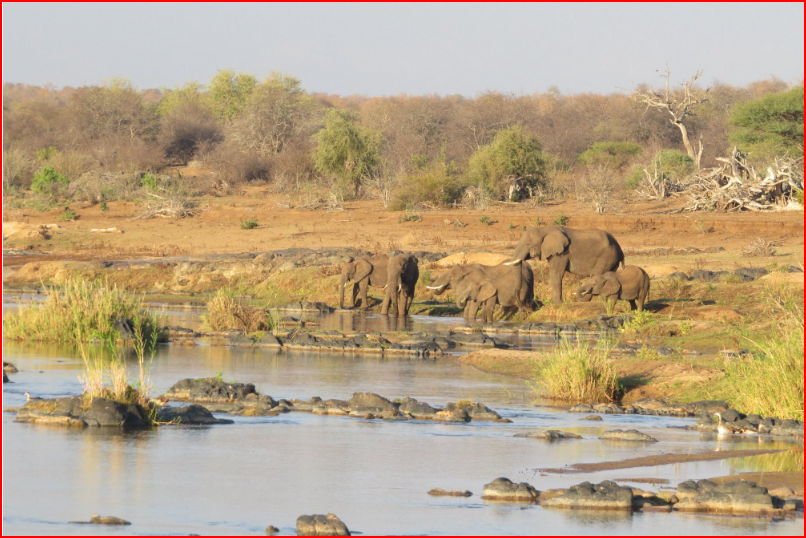
Olifants Trail -(photo in Banner above)
No huts, no frills, just raw African bush and an intimate encounter with wildlife on foot. Guided by two armed field rangers, groups of up to eight hikers carry all their own gear and camp in wild, undisclosed spots each night under the stars – expect hippos groaning by the river, fish eagles calling at dawn and bone‑deep solitude. The trail requires a medical certificate, gear check in advance and a take‑all‑your‑rubbish‑out ethic – it’s a transformational trek for those fit enough to carry their sense of adventure into the heart of Kruger.
Name Change Proposal-
It was reported recently that a motion was tabled on September 23 2025 by the Economic Freedom Fighters (EFF) in the Mpumalanga Provincial Legislature in which the party proposed that Kruger National Park be renamed to Skukuza National Park and the Kruger Mpumalanga International Airport be named the late former deputy president David “DD” Mabuza. The Department of Forestry, Fisheries and the Environment says there has been no name change for the Kruger National Park. The department was responding to recent reports that about a proposed change to the name. It added that those spreading misinformation are urged to refrain from doing so immediately! (link provided in Further Reading)
THE 2025 FLOODS- PLEASE READ UPDATES IN FURTHER READING
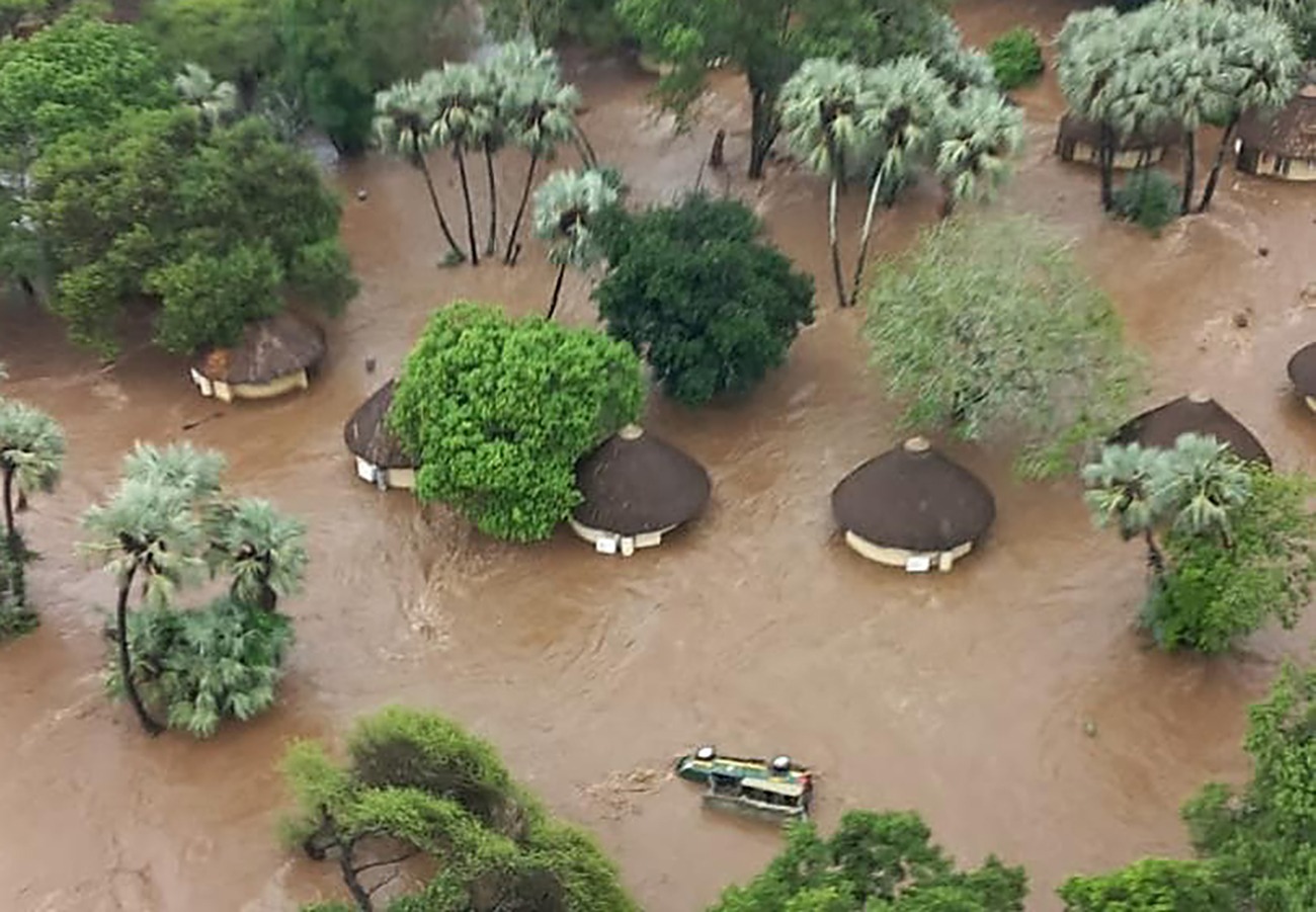
From management to rangers and pilots, South Africa’s most famous Big Five reserve, Kruger National Park, has called in all available hands to wrestle with the impact of persistent heavy rainfall across the Limpopo and Mpumalanga provinces.
Reynold Thakuli, spokesperson for Kruger National Park, described the situation as difficult for both staff and visitors.
Flood update: Officials remain on high alert at Kruger National Park
Celeste Martin15 January 2026 | 10:10Rising rivers have brought much of South Africa’s flagship park to a standstill

Heavy rainfall has forced widespread closures and evacuations across the Kruger National Park, with rising rivers cutting off access between large parts of the reserve.
SANParks spokesperson Reynold Thakhuli confirms that several camps and gates have been closed, including Crocodile Bridge and Letaba Rest Camp, as rivers burst their banks and key bridges were submerged.
"It's really bucketing down quite heavily here."
He adds that guests and staff have been evacuated from multiple locations, including Shingwedzi Rest Camp, which is now underwater, and the Rhino Walking Safari, where 27 guests were airlifted out as a precaution.