
Sandbank at the entrance to Natal Bay, Durban. Previously known as 'Lee Bank', it took its name from the barque, 'Annabella'. That ran aground on it on 26 January 1856. Subsequently the North Pier was constructed over this Sandbank!
placeREF P-0122012Revised
Place record
Annabella Sandbank, Durban Port
- Coordinates
- 31.2000, -29.5300
- Updated
- 20 Jul 2026
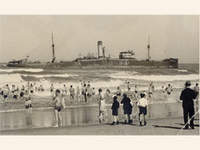
Vessel that Ran Aground Image source
Location Map
Annabella Sandbank, Durban Port
How we know this
- 01New Dictionary of South African Place Names by Peter E Raper
Last updated · 20 Jul 2026
South African History Online. (2016, September 23). Annabella Sandbank, Durban Port. South African History Online. https://sahistory.org.za/zu/ref/P-0122012
South African History Online (2016) 'Annabella Sandbank, Durban Port', South African History Online, 23 September. Available at: https://sahistory.org.za/zu/ref/P-0122012 (Accessed: 25 July 2026).
South African History Online, Annabella Sandbank, Durban Port [website], https://sahistory.org.za/zu/ref/P-0122012, (accessed 25 July 2026).
"Annabella Sandbank, Durban Port." South African History Online, 23 Sept. 2016, https://sahistory.org.za/zu/ref/P-0122012. Accessed 25 July 2026.
South African History Online. "Annabella Sandbank, Durban Port." South African History Online. September 23, 2016. https://sahistory.org.za/zu/ref/P-0122012.
Further reading
 Article
A list of South African Shipwrecks
Antipolis (1977)
The Antipolis, a Greek oil tanker, ran aground on the rocks near Victoria Road in Oudekraal in the....
 Place
Place
Durban Harbour and Port
Durban is the Capital City of the South African Province of KwaZulu-Natal, on the East Coast of the Country.
 Article
Maritime history and heritage: shipwrecks
Why are shipwrecks important?
Shipwrecks have always held a specific allure. The promise of hidden treasure, the...
 Place
Place
Durban, Kwa-Zulu Natal
Durban is South Africa’s third-largest City and one of the fastest-growing urban Areas in the World.
 Place
Place
Voices of Women Museum, Durban
This fascinating, living archival Museum holds within its walls some 3 000 embroidered cloths and personal stories from....
 Place
Place
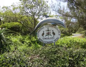
Umdloti, North Coast of Kwa-Zulu Natal
Umdloti is the ideal place to unwind and enjoy the sunshine with: 'beaches, rock pools and sea'.
SAHO is free because readers fund it. Donate →