
Locality some 15 km, South-East from Prince Albert. Takes its name from the Wild Carnation-Anglier in Afrikaans and the Dutch translation for bush, is 'bosch'.
placeREF P-0121994Revised
Place record
Anglierbosch, Western Cape
- Coordinates
- 22.7000, -33.1600
- Updated
- 1 Jun 2020
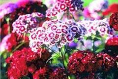
Wild Carnation Image source
Location Map
Anglierbosch, Western Cape
How we know this
- 01New Dictionary of South African Place Names by Peter E Raper
Last updated · 1 Jun 2020
South African History Online. (2016, September 23). Anglierbosch, Western Cape. South African History Online. https://sahistory.org.za/xh/ref/P-0121994
South African History Online (2016) 'Anglierbosch, Western Cape', South African History Online, 23 September. Available at: https://sahistory.org.za/xh/ref/P-0121994 (Accessed: 21 July 2026).
South African History Online, Anglierbosch, Western Cape [website], https://sahistory.org.za/xh/ref/P-0121994, (accessed 21 July 2026).
"Anglierbosch, Western Cape." South African History Online, 23 Sept. 2016, https://sahistory.org.za/xh/ref/P-0121994. Accessed 21 July 2026.
South African History Online. "Anglierbosch, Western Cape." South African History Online. September 23, 2016. https://sahistory.org.za/xh/ref/P-0121994.
Further reading
 Article
Western Cape Youth Uprising timeline 1976
1976
16 June, Extra police patrols are deployed.
24 June, The Principal's office in Hlangisi Primary (Nyanga)...
 Article
The Dutch Settlement
The region of the Western Cape which includes the Table Bay area (where the modern city of Cape Town is located) was...
 Place
Place
Good Hope Centre, Cape Town
"The aim of this lecture is to shed light on the Good Hope Centre in, Cape Town. An exceptional building designed by...
 Place
Place
Barrydale, Cape Overberg
The little Town of Barrydale lies nestled at the foot of the beautiful Langeberge in the heart of the Tradouw Valley,...
 Place
Place
Redelinghuys, Cape West Coast
Lying about two Hours' drive from Cape Town, Redelinghuys is known as the 'potato Capital', of the Sandveld.
 Article
June 16 Soweto Youth Uprising timeline: 1976-1986
1976
According to the government-appointed Cillie Commission of Enquiry 575 people died.
SAHO is free because readers fund it. Donate →