
The name in Khoi means 'red hill tree'. This refers to the Pepper Trees, the berries of which give a reddish apperance. Native to dry South America and cultivated in warm regions, like Namibia!
placeREF P-0121822Revised
Place record
Abbaheigaskop, Northern Cape
- Coordinates
- 18.0200, -29.1100
- Updated
- 16 Apr 2020
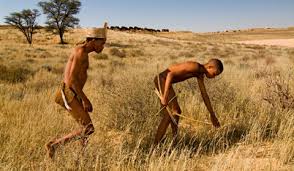
Khoi Men
Location Map
Abbaheigaskop, Northern Cape
How we know this
- 01South African Place Names by Peter E. Raper https://www.britannica.com/plant/pepper-tree
Last updated · 16 Apr 2020
South African History Online. (2016, September 14). Abbaheigaskop, Northern Cape. South African History Online. https://sahistory.org.za/xh/ref/P-0121822
South African History Online (2016) 'Abbaheigaskop, Northern Cape', South African History Online, 14 September. Available at: https://sahistory.org.za/xh/ref/P-0121822 (Accessed: 22 July 2026).
South African History Online, Abbaheigaskop, Northern Cape [website], https://sahistory.org.za/xh/ref/P-0121822, (accessed 22 July 2026).
"Abbaheigaskop, Northern Cape." South African History Online, 14 Sept. 2016, https://sahistory.org.za/xh/ref/P-0121822. Accessed 22 July 2026.
South African History Online. "Abbaheigaskop, Northern Cape." South African History Online. September 14, 2016. https://sahistory.org.za/xh/ref/P-0121822.
Further reading
 Place
Place
Northern Cape
The Northern Cape is the largest Province in South Africa, but has the least number of inhabitants.
 Archive
 Place
Place
Amikoob, a Plain in the Willomore Area; (Vogelstruisleegte)
Khoikhoi name of Vogelstruisleegte, a plain some 21 km North of Willowmore. The people who roam the Karoo, are the...
 Place
Place
Republic of Griqualand West or the Digger's Republic
Griqualand West was proclaimed as a separate Crown Colony . The discovery of diamonds in South Africa in 1866 resulted.....
 Place
Place
Greyton, Western Province
This Village of Greyton, in the Cape, was established in 1852. Although the first plots of land were only sold in 1854.
SAHO is free because readers fund it. Donate →