
placeREF P-0151955Revised
Place record
Nigel, an East Rand Mining Town
- Coordinates
- -26.4248, 28.4649
- Updated
- 20 Jul 2026
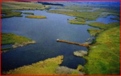
The Marievale Bird Sanctuary is Situated in the Southern Half of the Blesbokspruit RAMSAR site. This is Also an Important; Bird Area in South Africa.
The Town of Nigel began as a gold Mining Town in the late 1800's. It was named after a book the Prospector, (which is a person who searches for mineral deposits)-Sir Walter Scott, happened to be reading at the time. This books name was: 'The Fortunes of Nigel'. This Town is directly South of Springs and Brakpan and lies in what is known as the East Rand, South East of Johannesburg. Whilst there Gold Mines have recently been closed, the Industrial Area of the Town is responsible for the manufacturing of the Gautrain Rail Cars. Theses were dispatched from the Industrial Area of Nigel, in 2008. Electricity Hardware and Towers are still manufactured here. They then distribute these specialty transformers; electric motors, generators and motor-generator sets, switchgear and switchboard apparatus, relays and industrial controls. The Marievale Bird Sanctuary is situated in the Southern half of the Blesbokspruit RAMSAR site, or Wetland Area. It is also a designated Important Bird Area in South Africa. Blesbokspruit is the only Ramsar Wetland in the Gauteng Province. It is situated 4 km outside Nigel, the Highveld Town is at an altitude of 1,585 m. RAMSAR Sites are Wetlands of International importance, that have been designated under the criteria of the Ramsar Convention on Wetlands for protecting rare or unique Wetland types or for conserving biological diversity. (This convention was held in India, hence the name!) The Marievale Bird Sanctuary is about 10 km2 in size and comprises numerous, large, shallow water bodies dominated by tall, at times dense stands of emergent vegetation consisting mainly of Phragmites, Typha and Juncus reeds. (These types of Reed are used to encourage microorganisms growth and treat wastewater!)
Location Map
Nigel, an East Rand Mining Town
How we know this
- 01http://www.nigel.co.za/marievale/ https://www.sa-venues.com/attractionsga/nigel.php
Last updated · 20 Jul 2026
South African History Online. (2023, March 10). Nigel, an East Rand Mining Town. South African History Online. https://sahistory.org.za/ss/ref/P-0151955
South African History Online (2023) 'Nigel, an East Rand Mining Town', South African History Online, 10 March. Available at: https://sahistory.org.za/ss/ref/P-0151955 (Accessed: 22 July 2026).
South African History Online, Nigel, an East Rand Mining Town [website], https://sahistory.org.za/ss/ref/P-0151955, (accessed 22 July 2026).
"Nigel, an East Rand Mining Town." South African History Online, 10 Mar. 2023, https://sahistory.org.za/ss/ref/P-0151955. Accessed 22 July 2026.
South African History Online. "Nigel, an East Rand Mining Town." South African History Online. March 10, 2023. https://sahistory.org.za/ss/ref/P-0151955.
Further reading
 Article
A Land Dispossession History 1600s-1990s
Anyone who travels over the vast expanse of South Africa is immediately struck by the great variations in its landscape....
 Article
Rand Rebellion 1922
The Rand Rebellion of 1922 was an armed uprising that is also referred to as the Rand Revolt or Red Revolt.
 Article
1946 African Mineworkers Strike
"Two hundred thousand subterranean heroes who, by day and by night, for a mere pittance lay down their lives to the...
 Biography
Hemant Kumar Waghmarae
Hemant Kumar Waghmarae was born on 24 October 1948 in Mumbai, India to Vishnu Maroothi Waghmarae and Indumati Bane...
 Biography
Tikkie Sibisi
Tikkie Sibisi was born in Greater Nigel in 1975 and grew up in Duduza Township with a single parent, his father, and...
SAHO is free because readers fund it. Donate →