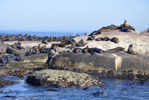
Hout Bay has now become well known as the port of departure for scenic day trips to Seal island or Duiker Island, home to a colony of thousands of Cape Fur Seals. Drumbeat Charters, has been offering daily scenic cruises to Duiker Island to see the Cape Fur Seals from Hout Bay since 1989. The cruises are offered in either an open boat that holds 60 passengers or aboard their flagship vessel holding 120 passengers. Cruises vary between 40 minute trips and 1 hour trips, the latter of which return via the Kabonkelberg mountain range to see the shipwreck at Maori Bay or via the caves and cliffs of Chapman’s Peak. When boarding the Drumbeat II, enjoy a glass of wine or an ice cold beer from the vessel’s on board bar facilities. Should you prefer to take your own drinks on board, this is also permitted. The boat has ample outside and undercover areas and individual seating.
Breeding time for Cape Fur seals generally takes place in November/December but on Duiker Island you will see mainly male seals waiting to “come of age” for breeding. The Duiker island colony is not a breeding colony as the island has very rough waters with the risk of washing away the pups. Between January and March you will see the most seals with over 6000 Cape fur Seals populating the island as well as a variety of seabirds and cormorants. Enjoy watching the seals lazily rolling around on the rocks, snorting and groaning with the larger males competing aggressively for dominance & others sliding off into the cold waters with fins held high as if throwing a wave to the passing boats