The Portuguese arrived in the area in 1488, followed by the British in the 1820's. The region was the site of frequent wars and skirmishes between the Khoisan, Xhosa, and European settlers. Its history is intertwined with the broader history of the region, including its Xhosa heritage and its role as a frontier town and later a part of the British Cape Colony.
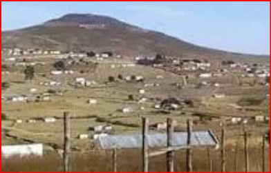
Ntabankulu is an isiXhosa word meaning "great or big mountain", since the municipal Area is mountainous in character. The Municipality was established with the name: 'Ntabankulu' and the village itself was laid out in 1909, though a General Store existed on the site as early as 1894. Ntabankulu is located in the Eastern Cape province of South Africa, is situated in a region with a complex and conflict-ridden history involving interactions between various groups. The Eastern Cape was one of the first areas colonized by the Portuguese and later by the British, and it also saw numerous clashes between the indigenous Khoisan and Xhosa people, as well as conflicts with European powers. The British, Dutch, and Germans all played a role in the region's history through colonization, trade, and conflict.
The Ntabankulu Local Municipality is a Category B Municipality situated within the Alfred Nzo District in the Eastern Cape Province. It is the smallest of the four Local Municipalities in the District, accounting for 13% of its geographical area.
It was formerly part of the OR Tambo District Municipality, but was transferred to the Alfred Nzo District Municipality after the 2011 municipal election. This is a local Municipality in the Eastern Cape, not a designated Group Area. It is one of the 205 Local Municipalities in South Africa. The Municipality covers an area of 1,385 km² and is primarily known for Agriculture, sand and quarry Mining, Forestry, and Tourism.