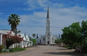
A party of 256 from London led by Lieutenant John BAILIE, R.N. sailed in "Chapman". Their locations was between the Wellington and Palmiet Rivers and their centre was named Cuylerville after Colonel Jacob CUYLER, 59 Regiment. Divisions of the party were directed by Lieutenant BAILIE, Thomas ADAMS, George ANDERSON, William HARRISON and Thomas WAKEFORD.
Settler Handbook Content: No. 33 on the Colonial Department list, led by John Bailie of 7 Manchester Buildings, Westminster, London, a civil servant who had held the position of Secretary to the British War Claims Commission. Bailie was introduced to the Colonial Department by an influential patron, William Huskisson, MP for Chichester, Commissioner for Wood and Forests and a former Under-Secretary to the Colonial Department, and his application to emigrate was one of the first to be accepted.
This was one of the three large joint-stock parties (Bailie's, Sephton's and Willson's) with a high proportion of skilled tradesmen and professional men, which were intended to form 'village centres' in the new Albany settlement.
The Chapman was the first of the settler ships to anchor in Algoa Bay on 10 April 1820. William Low, one of Bailie's servants, did not land with the other settlers but remained on the ship as a sailor. Another servant, Christopher Franz, and Daniel Hockly, WD Cowper and John Leonard were offered employment while at Algoa Bay and permitted to leave the party. The remainder of the party was escorted by the Landdrost of Uitenhage, Colonel Cuyler, to its location at the mouth of the Great Fish River. Sixty-four one-acre lots were measured for a village which was named Cuyler Town (later Cuylerville).
There is a Cuyler Street in the city of Grahamstown.
A toposcope and commemorative cairn in Bathurst mark the spot where Cuyler made his camp while supervising the placing of the 1820 Settlers on their locations. While camped here at the same time Sir Rufane Donkin chose the site for the administrative centre to be named Bathurst. The beacon was erected by Captain W. Bailey as an observing station during his survey of the eastern districts, 1855-1859.