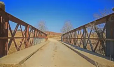
The Sivewright Bridge, in Station Street. Is a National Monument With its magnificent, Sandstone Bridge With Arches.
This place was first known by the by the San People as; 'Nqarhu'. When however the Colonialists established the Town they named it Maclear. (These Colonists were shipwrecked, after looking for a sea-route to India.) The route they followed passed a few miles South of Maclear. According to all Historical records they were the first Europeans ever to enter the Area.
A portrayal of this procession was painted by the San in a cave on the Farm of' Ben Strachan'. This is located in the Inxu Gorge ward of the present Maclear District. During 1895, this and adjoining Farms were cut off from Maclear and incorporated into the Tsolo district. Dinosaur Footprints were discovered on this Farm; 'Oakleigh'.
This Town is situated in the Eastern Cape province, near Mooi River. Which is approximately 172 km North of East London and 80 km North-East of Elliot.
This Town is situated in the Eastern Cape province, near Mooi River. Which is approximately 172 km North of East London and 80 km North-East of Elliot.