
Historical aerial photo of District Six
imageREF I-0100305Revised
Image record
Historical aerial photo District Six
- Format
- Images
- Updated
- 24 Jul 2019
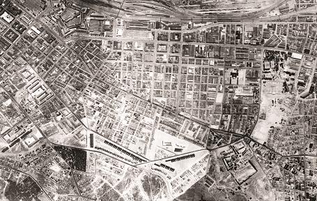
Source from the District Six Museum: Lucien le Grange Architects & Urban Planners, District Six Heritage Impact Assessment, 2003.
South African History Online. (2016, February 16). Historical aerial photo District Six. South African History Online. https://sahistory.org.za/ref/I-0100305
South African History Online (2016) 'Historical aerial photo District Six', South African History Online, 16 February. Available at: https://sahistory.org.za/ref/I-0100305 (Accessed: 5 September 2026).
South African History Online, Historical aerial photo District Six [website], https://sahistory.org.za/ref/I-0100305, (accessed 5 September 2026).
"Historical aerial photo District Six." South African History Online, 16 Feb. 2016, https://sahistory.org.za/ref/I-0100305. Accessed 5 Sept. 2026.
South African History Online. "Historical aerial photo District Six." South African History Online. February 16, 2016. https://sahistory.org.za/ref/I-0100305.
Further reading


 Article
The ANC’s MK Special Ops Unit Material - Yunus Carrim Collection - 6 November 2025
The ANC’s MK Special Ops Unit Material Yunus Carrim Collection 06 November 2025 What is this about? The...


 Place
Place
Oyster Bay
Oyster Bay or “Oesterbaai” in Afrikaans, is a small coastal hamlet and resort located about 22.5 kilometres (14.
SAHO is free because readers fund it. Donate →