The Outeniqua Pass is a relatively modern Pass, connecting the Coastal Town of George with Oudtshoorn and the Little Karoo.
It was first built in 1942 - 1951 to provide an alternative to the narrow and steep Montagu Pass. It has been widened and modernized several times since then and today carries the bulk of the traffic flow, between the two Towns and the Langkloof Valley. It forms part of the Cape Fold Belt. This belt is a 1300 km long, Mountain belt along the Western and Southern Coastlines of South Africa.
The Langkloof Valley and Mountains are a short range of mountains that serve as a link between the Tsitsikamma and Outeniqua Mountains. In the Valley below is an Area that stretches about 160 kilometers and is ideal for growing fruit, particularly apples and pears. Dotted in amongst the fruit trees of fruit Farms in the Area, are a selection of little Towns , most of which lie on Route 62.
Joubertina is the main business Town, formed initially on the 'Langkloof Farm'. This is one of few Towns in the Area where the original law prohibiting the ban of the sale of alcohol was never lifted, but not necessarily in evidence any more, in the Town. Rockfalls and trucking accidents close the Pass, from time to time. The higher reaches of the Pass are subject to heavy rainfall and dense Mountain mists which can reduce visibility to a few meters. Under such conditions, this Pass is dangerous especially due to the volume of commercial traffic that it carries!
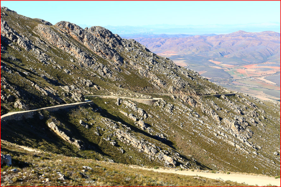
It contains 40 bends, corners and curves, many of which exceed 90 degrees. The road is well engineered, but it is advisable to stick to the speed limits which have been carefully calculated, to get you safely over the Pass. For South-bound traffic there are several excellent view-sites and the third one from the summit is particularly impressive, which is marked as "The 4 passes". From this vantage point all four passes can still be seen, one of which dates back almost 200 years.
SOME COMMENTS FROM TRIP ADVISOR-
"Beautiful pass to drive through, it does get cloudy in the afternoons so ensure you go in the morning or hedge yourself in case you need to drive it a couple times before you can enjoy the views."
"Very cool views. I think there were 3 places to stop and park, each with picnic tables. If you follow the directions on Google Maps, it will take you too far past the viewpoints. Recommend a quick stop if you're in the area."