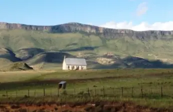
The Village of Clumber was established on land allocated in 1820 to Dr Thomas Carlton, leader of a party of settlers from Nottinghamshire. In October 1893 its name was changed to Trappes Valley, and soon after, in November 1893, another Village, also called Clumber was established on a site some 20km away from the original.
Place record
Clumber, Eastern Cape
- Coordinates
- 26.8500, -33.4300
- Updated
- 28 Sep 2020

Second Church erected later Image source
Location Map
Clumber, Eastern Cape
South African History Online. (2011, March 16). Clumber, Eastern Cape. South African History Online. https://sahistory.org.za/ref/P-0013751
South African History Online (2011) 'Clumber, Eastern Cape', South African History Online, 16 March. Available at: https://sahistory.org.za/ref/P-0013751 (Accessed: 21 July 2026).
South African History Online, Clumber, Eastern Cape [website], https://sahistory.org.za/ref/P-0013751, (accessed 21 July 2026).
"Clumber, Eastern Cape." South African History Online, 16 Mar. 2011, https://sahistory.org.za/ref/P-0013751. Accessed 21 July 2026.
South African History Online. "Clumber, Eastern Cape." South African History Online. March 16, 2011. https://sahistory.org.za/ref/P-0013751.
Further reading
Lady Grey, Eastern Cape
Queenstown, now known as Komani.
Fort Glamorgan, East London
Fetcani Pass, Eastern Cape
Ghwarrie Poort
SAHO is free because readers fund it. Donate →