Sahlumbe, a Settlement along the Tugela River, about 23km from Weenen and on the edge of Msinga which was a District, established in the former Homeland of; KwaZulu. It is situated on Land that is rough, arid and isolated when compared to other relocation sites along the Tugela River, on Trust Land. These sites included Nomoya, Msusamphi and Mashunka were former white Farms acquired in the mid-1960's for purposes of relocating people evicted from elsewhere. From the late 1960's onwards, their purpose as a combined relocation area for the many former Weenen Farm Workers began in earnest.
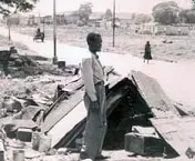
Sahlumbe was formally created in 1969 by the State, in response to a crisis sparked by the eradication of Labour Tenancy in Weneen. Arrivals to the area began in the 1960's and continued throughout the decade as Evictions from Labour Tenants were increasingly being evicted from Weenen’s white farms. The conflict between Labour tenants and white Famers in Natal arose because the former opposed to efforts to introduce a full-time Farm Labour System in the Province. Approximately 20 000 Weneen Labour Tenants refused to sign full-time Permanent Labour Contracts that complied with the New System. As a consequence of their resistance they were Evicted from the District. Thus, by 1970 the area had an even larger population. Few people in Sahlumbe had steady Houses, while many others lived in Tents and the few remaining only had temporary accommodation. There was no reliable Water Supply and people were dependent on the Tugela River, which was polluted and hard to access. Instead, Water Supplies for a long while came from a few nearby streams and springs, that were far from abundant. In 1980-81, during a severe drought, many Streams and Springs had totally dried up. In KwaZulu-Natal especially, the removal of thousands of people into closer Settlements had violent repercussions. Factional violence whose origins and causes were varied broke out. Amongst these clashes over access to Land, was a major factor. The crowding of people over a small Area resulted in Landlessness, overloading and competition for insufficient Resources. This was compounded by new arrivals to the Area.