
The area, known as the Malay Quarter of Cape Town, nestles against the steep slopes of Signal Hill. It formerly covered a much larger piece of land but this has been restricted over the years by incursions from commercial development and the threat of Apartheid legislation. It is one of the oldest parts of Cape Town, and is one of the few to have retained some of its historical character. It originated during the third quarter of the 18th century, when Cape Town began to expand along an east-west axis. The first houses in this neighborhood were probably built in 1790 but between 1795 and 1820 an increasing number of lower income families including many artisans began to make their homes here. The influx of Malays into this quarter probably began in the 1830s when slavery was abolished and Malay residents who had been forcibly brought to the Cape began to make their homes there, and by the middle of the 19th century it was already known as the Slamse Beurt, or the Islamic Quarter. It owes much of its character to the nature of its domestic architecture, mostly single storey houses with flat roofs painted in a variety of pastel colours. A number of mosques with picturesque minarets are still in daily use. The Quarter was probably a major factor why the Cape Malay community managed to retain its identity as a group. Unfortunately the quality of its environment began to deteriorate after WWI, and in 1944 it was declared a slum. This led a number of prominent Cape Town citizens to form a group for the retention of the Malay Quarter, with the support of both the then Historical Monuments Commission as well as the City Council. Initially much of the suburb was purchased by the City Council, but as public opinion began to swing in its favour, so then the Government began to set aside funds for the rehabilitation of this area. It was declared a National Monument under old NMC legislation on 15 April 1966.
Place record
Malay Quarter, Cape Town
- Coordinates
- -33.9177, 18.4113
- Updated
- 20 Jul 2026
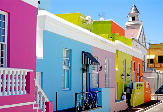
The Brightly Coloured Homes of the Bo-Kaap, in the Malay Quarter today Image source
Location Map
Malay Quarter, Cape Town
South African History Online. (2011, July 14). Malay Quarter, Cape Town. South African History Online. https://sahistory.org.za/nso/ref/P-0065738
South African History Online (2011) 'Malay Quarter, Cape Town', South African History Online, 14 July. Available at: https://sahistory.org.za/nso/ref/P-0065738 (Accessed: 22 July 2026).
South African History Online, Malay Quarter, Cape Town [website], https://sahistory.org.za/nso/ref/P-0065738, (accessed 22 July 2026).
"Malay Quarter, Cape Town." South African History Online, 14 July 2011, https://sahistory.org.za/nso/ref/P-0065738. Accessed 22 July 2026.
South African History Online. "Malay Quarter, Cape Town." South African History Online. July 14, 2011. https://sahistory.org.za/nso/ref/P-0065738.
Further reading
 Article
Cape Town the Segregated city
 Article
The Freedom struggle in Cape Town
 Article
Cape Town Timeline 1300-1997
 Article
Slave Resistance
 Article
Cape Youth Congress (CAYCO)
 Article
United Women’s Organisation (UWO)
SAHO is free because readers fund it. Donate →