Matroosfontein

This Area was established in the Years of Apartheid! It is perfectly positioned; as it is extremely close to the Cape Town International Airport (less than about four kilometres, in fact) and is fewer than 20 kilometres from the City Bowl. This Suburb has a deep, poignant History, and is a fascinating Area, to explore and discover. Originally, home to larger segments of the Coloured Community and Working Class! It now has developed into an Area that showcases the food, music, beliefs and faces of these folk. Matroosfontein Population is now a full spectrum of the South Africans. Bordering on: the Township of Gugulethu, Bonteheuwel, Elsie’s River, Goodwood, Athlone, Belhar and Parow Industrial. Matroosfontein is just one more of the Areas that define the character and charm of Cape Town and South Africa, and offers locals and visitors alike the opportunity to tour this unique place!

Geolocation
-33° 33' 36", 18° 21'

Bonteheuwel

Bonteheuwel is a coloured Township situated North of Cape Town. It was created in the 1960's as a "Dumping Site" for coloured people, who had been forced to move out of Cape Town. This was a result of the Group Areas Act of 1950, were the land was divided into: blacks and whites distinct residential zones, the beginning of Apartheid! This act established the distinct areas of South Africa in which members of each race could live and work, typically setting aside the best urban, industrial, and agricultural areas for whites. The area was conceived as a letting scheme owned by the then Cape Town City. The construction of housing in Bonteheuwel (proper) started in 1961 and was completed in 1964.
In the 2001 national census, Bonteheuwel had a population of 55 707, of whom 95% were classified as coloured and 4% as Black African, indicating the results of the Group Areas Act. Afrikaans is the dominant language at 76%, while English is spoken as a home language by a further 22%. The housing profile of Bonteheuwel is dominated by brick houses on separate stands in which 72% of the population lives, followed by semi-detached houses in which a further 11% of population lives, while backyard dwellings – both brick structures and informal dwellings – are home for a further 11% of the people.
This Area is Bonteheuwel is a coloured Township situated North of Cape Town. It was created in the 1960's as a "Dumping Site" for coloured people, who had been forced to move out of Cape Town. This was a result of the Group Areas Act of 1950, were the land was divided into: blacks and whites distinct residential zones, the beginning of Apartheid! This act established the distinct areas of South Africa in which members of each race could live and work, typically setting aside the best urban, industrial, and agricultural areas for whites. The area was conceived as a letting scheme owned by the then Cape Town City. It comprised four areas, namely Bonteheuwel (proper), Bluegum, Netreg and Kalksteenfontein. The construction of housing in Bonteheuwel (proper) started in 1961 and was completed in 1964.
In the 2001 national census, Bonteheuwel had a population of 55 707, of whom 95% were classified as coloured and 4% as Black African, indicating the results of the Group Areas Act. Afrikaans is the dominant language at 76%, while English is spoken as a home language by a further 22%. The housing profile of Bonteheuwel is dominated by brick houses on separate stands in which 72% of the population lives, followed by semi-detached houses in which a further 11% of population lives, while backyard dwellings – both brick structures and informal dwellings – are home for a further 11% of the people.
This Area is predominantly is made up of financially and impoverished, struggling community!

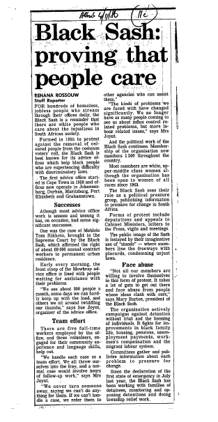
Bonteheuwel's Freedom Square is now officially a Provincial Heritage Site. The square, in the suburb's central business district (CBD), holds historic significance. It is the place where anti-apartheid freedom fighters often gathered to strategize and organise. During the liberation struggle, Freedom Square was a space for congregation and political meetings. The Bonteheuwel Civic, the library, the staircases and platforms surrounding the library would act as assembly and meeting points, which provided a platform for activists to address crowds.

Geolocation
-33° 57' 3.6", 18° 32' 13.2"

Princess Vlei Conservation Area

Before the arrival of European settlers, it was a watering ground for early Khoi herders. The first encounter between these herders and Europeans was with the battle against Fransisco D’Almeida, which has been linked to the legend of a Princess. The legend goes; that this Khoisan Princess was abducted by Portuguese sailors while bathing in its waters.
During the years of Apartheid, it became one of the few natural Areas that people of colour could visit, after they were forcibly removed by the Government to Housing Estates on the Cape Flats. This Vlei was severely neglected by the authorities, and became further degraded when a road was built through it, with little regard for conserving its ecology!
The Khoi and the San were Cape Town’s earliest inhabitants, forcibly enslaved or driven out by those who came later. The Vlei remains an important site for celebrating and memorialising this Heritage by many Khoi cultural revivalist groups. When theses people classified as coloured and black were forcibly removed to the Cape Flats by group areas, this was the one of the few natural places they could come to relax and enjoy picnics with their families. Since people were denied access to the beaches, Princess Vlei become known as 'Claremont beach' or 'Gala land'.

It has long been used as a place for water immersion Baptism. Church groups come every Sunday from Nyanga, Gugulethu, Philippi….At Easter, they come from as far afield as Gauteng, baptising hundreds in a morning. Many others come to the vlei to be close to God and nature.
The vlei offers a venue where local Capetonians from all walks of life can enjoy nature together. Located between formerly coloured and white Areas, it is perfectly situated to build community, overcome Historical divisions and bring people together.
The Vlei provides a valuable public space to communities facing socio-economic challenges in highly urbanised environments. This space reconnects urbanised communities with nature, and an outdoor classroom where youngsters can experience and develop an appreciation of and love for nature.
The Princess Vlei provides a habitat for many plants and animal species and nurtures biodiversity. As human pressure on natural resources increases, our continued existence is under threat if we do not find a way to live more sustainably. The sustainable City of Cape Town, works closely with nature, nurturing biodiversity and allowing natural systems such as wetlands to exist!

After 12 years of being in the the placement of an official Heritage Site; a plaque has been laid at the Princess Vlei. This declares that Princess Vlei is a Provincial Heritage Site. This occurred on Tuesday 12 October.

Geolocation
-34° 2' 49.2", 18° 28' 44.4"

About SAHO

South African History Online  was established in 1998 and registered in June 2000 as a not for profit Section 21 organisation. We have become the largest and most comprehensive online website on South African and African history and culture.  In 2019 the website was used by 6.3m local and international visitors.

SAHO is a unique history project – our website, the organisation’s flagship project, is linked to a partnership programme with universities, community based history projects, educational and the cultural department of government.

Our mission is to write a new history which would break the silence on our past and to address the biased way in which the historical and cultural heritage of South Africa and the continent has been represented in our educational and cultural institutions.

We have committed ourselves to building, a non-partisan, peoples history project in partnerships with academic, heritage and community groups in South Africa and from the rest of the African continent.  

Classroom

The Online Classroom is the mainstay of SAHO's schools History Project, which comprises of a number of inter-related projects aimed at popularising and strengthening the teaching of the new history and other subject areas curriculum requirements.  The online classroom consists of the history curriculum for grade 4 to grade 12.

Biographies

SAHO’s biography project is one of the largest in South Africa.  It includes biographies of people who have played a significant role in the Liberation Struggle in South Africa. The “Lives of Courage Project”, is an online “Wall of Remembrance” of people killed in the struggle against Apartheid in South Africa.

Communities

SAHO has developed links with community-based projects We have assisted community groups to build their own websites, which has enabled communities to market their heritage sites, local histories and festivals online. This programme has the potential to create jobs and promote tourism.

Archives

The SAHO archive is a unique feature of its website.  It contains more than 50.000 documents, videos and images and acts as an invaluable resource for furthering new research. The material in the archive is linked to features, articles, biographies and the history classroom on the website.

Internship Programme

We are committed to building partnerships with institutions of higher education so that they can draw on the expertise of our educational institutions and on all our resources to contribute to knowledge production that supports the teaching and learning of history and to ensure the integrity of our content.

Oral History Competition

SAHO and the Department of Basic Education (DBE), jointly, run the annual Chief Albert Luthuli Young Historians Oral History Competition. This is a national oral history project, which invites learners and educators to undertake oral history projects on people who fought for freedom and those who are promoting democracy in their communities.

Exhibitions

SAHO has an online and a travelling exhibition programme. We have, over the past 20 years, organised a number of seminal exhibitions that have travelled locally and internationally. SAHO has also assisted artists and photographers with the designing, printing and marketing of their work.

Mafika Gwala Lectures

In 2016, SAHO launched the annual Mafika Gwala Lecture in partnership with the University of KwaZulu-Natal (UKZN) and the National Institute of Humanities and Social Science (NIHSS). As part of the annual lecture programme, we began a school’s essay writing competition with 14 schools in Hammarsdale Township outside Durban, KwaZulu-Natal (KZN).

 SAHO Board

  • Ashraf Dockrat
  • Pippa Green
  • Nazeema Mahomed
  • Xolelwa Kashe-Katiya
  • Omar Badsha, founder and CEO

Contact Us

Tel: 

+27 (0)21 447 4365

Address:

349 Albert Road,  

Woodstock 7925    

Cape Town,  South Africa

Email:  info@sahistory.org.za