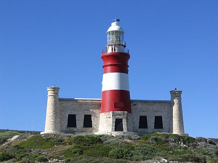
Cape Agulhas is some 32 km South of Bredarsdorp. The name is Portuguese for 'needle' and is said to have been given because the compass needle was seen to point due north and that is with no magnetic deviation. Therefore the Portuguese name of 'Cabo das Agulhas' was given. The Agulhas Bank extends for 250km at a depth of only 60m, and then plunges to 1800 m, a depth it maintains all the way to the Antartic. It is reputed to be, the richest fishing area in the Southern Hemisphere!
Unlike its better known relative, the Cape of Good Hope. The Cape Agulhas is relatively unspectacular, consisting of a gradually curving coastline with a rocky beach. The lighthouse was built because an increasingly large number of international ships, were succumbing to the thick coastal fog and treacherous sees and getting ship wrecked on this Bank! Michiel van Breda owner of the farm, 'Zoetendalsvlei' which is the name of the first recorded shipwreck in 1673. He was very influential in the area and founded Bredasdorp, in 1838. He campaigned tirelessly for a lighthouse to be built in the area and eventually, donated the land, on which it was to be built!
The rocks that form Cape Agulhas, belong to the Table Mountain Group which are often loosely termed; 'Table Mountain Sandstone'. These rocks are closely linked to the geological formations that are exposed in the spectacular cliffs of: Table Mountain; Cape Point and the Cape of Good Hope. The lighthouse was declared a National Monument in 1973 and is open to the public!
 The lighthouse at Cape Agulhas has guided many ships around the Cape over the years Image source
New Dictionary of South African Place Names by Peter E. Raper.
Lighthouses of South Africa by Gerald Hoberman.