The Pretoria region was initially occupied by the southern Ndebele people, led by Chief Musi. They inhabited this area about 300 to 400 years ago.
The period from 1820 to 1832, known as the Mfecane or Difeqane, was characterized by great strife among the black communities in Southern Africa. This turmoil also changed the patterns of settlement and influenced the ethnic structure of the African population north of the Vaal. The Mfecane began as a result of the movement of several Nguni groups across the Drakensberg from KwaZulu Natal, in order to escape Zulu expansion.
Mzilikazi, a general who had fled from King Shaka's army, was the cause of much of the destruction of the smaller tribes in the area across the Vaal.
Not long after his arrival, Mzilikazi decimated the Bakwena tribe, who had peacefully occupied the area. He also wiped out the Ba-Hurutsi for hundreds of miles around him. Mzilikazi wielded a path of destruction as far as the Orange River, annihilating all earlier inhabitants of the area. The men from these tribes were killed while the young boys and girls were incorporated into the Matabele fold.
Mzilikazi took up all the surrounding tribes as far as the Orange River to the south and Mozambique on the north east, including Bechuanaland.
Mzilikazi made Pretoria his home by building two military kraals on the Apies River: "enDinaneni" was situated north-west of Pretoria on the road to Hartebeespoort Dam and "enKungweni" was built along the Daspoort range of hills.
His main residence was on the south side of Meintjieskop, but he later moved to the north of the Magaliesberg range, to a place named "emHlahlandlela".
However, in 1836 it was reported to Mzilikazi that thousands of White people were moving southwards to invade his land. Feeling threatened, Mzilikazi launched a devastating attack on the Voortrekkers, led by General Hendrik Potgieter. The Voortrekkers managed to ward off their attackers after suffering great loss of life and livestock.
Shortly after this, Mzilikazi launched a second attack on the Voortrekkers, and this time his men carried off all the livestock owned by the Whites.
Potgieter, determined to succeed, launched a counter-attack on the Matabele at Mosega and managed to recover a considerable number of their livestock. In December 1837, Potgieter launched another attack on Mzilikazi and his tribe. This battle, together with the one waged by Dingane a few months earlier, was enough to send Mzilikazi fleeing across the Limpopo. With Mzilikazi out of the way, it was easy for Potgieter to drive the rest of the Matabele stragglers to the north over Silkaatsnek.
Although some Tswana tribes returned to the Apies River area after the departure of the Ndebele, there is no evidence of large communities occupying the area that is now the Pretoria municipality. The first White inhabitants to settle in Pretoria, in 1840, were the brothers Lucas and Gert Bronkhorst, who registered the farms "Groenkloof" and "Elandspoort."
Groenkloof encompassed the Fountains Valley area, while Elandspoort extended from the south to Daspoortrand in the north and from Pretoria west through to Hatfield in the east.
Later, a trek led by Andries Pretorius from Ohrigstad, together with a few stragglers from Natal and the OFS, also settled in the area.
It was through the efforts of Pretorius that the British recognized the independence of the Voortrekkers north of the Vaal, an area that became known as the Transvaal. This resulted in the signing of the Sand River Convention in 1852.
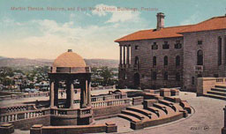
In 1853, the son of Andries Pretorius, Marthinus Wessels Pretorius, purchased two farms, Elandspoort and Koedoespoort, with the intention of founding a town that would be the centre of the new state. On November 1853, the two farms were declared a town, which came to be known as Pretoria.
An archeological look at the prehistory of the Pretoria area
The legislative capital of South Africa is named after the trek leader, Andries Pretorius, who moved into the area in about 1848. Some 20 years before that, Mzilikazi had stayed in the area and before then, it was home to the Southern Ndebele of the Manala division. The name of the Municipality, Tshwane, evidently comes from a legendary Manala chief.
Stonewalled settlements associated with Manala, as with other Southern Ndebele, derive from the Moor Park type first developed in KwaZulu-Natal (see pre history of Durban). Using this pattern, Ndebele specifically chose hilltops and hill slopes so that their settlements could emphasise the front/back axis. Such settlements could date back as early as the mid 17th century.
Some 100 years earlier, African farmers in the Fokeng cluster built stonewalled settlements in the Tshwane area that emphasised the centre/side axis. From the air, these earlier settlements resemble a 'fried egg'; that is, a smooth outer ring about 60 metres across enclosed in a central cattle byre about 20 metres in diameter. This type has its origins among BaFokeng living near the hill Ntsuanatsatsi in the Free State (see pre history of Bloemfontein). When these early BaFokeng people moved north across the Vaal River, they met the ancestors of Southwest Sotho-Tswana, such as BaRolong and BaThlaping. Their interaction helped to create a new type of stonewalling called Klipriviersburg. Besides Johannesburg, Klipriviersburg walling is also found around Pretoria. All of these people were mixed farmers; that is, they herded cattle as well as sheep and goats, and they cultivated sorghums, millets and various beans and peas. They were also capable of making metal tools and jewellery.
The earliest evidence of metal working in the region comes from the site Broederstroom west of Pretoria. Archaeologists have uncovered the remains of at least two stratified villages there that date back to between AD 550 and 700, each with evidence of iron forging. Two major technological steps characterise ancient iron production: smelting and forging. Technically, iron ore is reduced in a furnace to create a bloom. During this smelting process, silica in the host rock melts, flowing off as slag leaving the bloom behind. The bloom has to be forged in an oxidised atmosphere, usually in an open hearth. In both smelting and forging, bellows attached to clay pipes help the operators reach the necessary high temperatures. Culturally, Bantu-speaking people in the recent past compared the smelting process to childbirth, a private and sacred affair. Consequently, the smelter was usually secluded outside the settlement. Forging, in contrast, was comparable to raising the child; and so the forge was located in a public area in the centre of the homestead. The forges at Broederstroom follow this pattern.
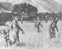
Archaeologists have also found some of the first formal stone tools in the world in the Pretoria area. Earlier Stone Age people (probably Homo ergaster) used the quartzite ridge above the zoo as a quarry for the manufacture of tools such as handaxes and cleavers (see pre-history of Southern Africa). Excavations for the Zambezi Drive toll gate at the east end of the ridge uncovered the same kinds of ancient artefacts. The artefacts in the quarry and activity area could be as much as a million years old.
This paper was written for SAHO in 2010 by Prof T.N. Huffman from the Archaeology Department at the University of the Witwatersrand.
For Further Reading:
- Herbert, E.W. 1993. Iron, Gender and Power: Rituals of Transformation in African Societies. Bloomington: Indiana University Press.
- Mason, R.J. 1962. The Prehistory of the Transvaal. Johannesburg: University of the Witwatersrand Press.
- Mason, R.J. 1981. Early Iron Age settlement at Broederstroom 24/73, Transvaal, South Africa. South African Journal of Science 77: 401-416.