The Griqua people’s history is not directly intertwined with that of Bloemfontein, however their history had an important influence on the history and development of the Orange Free State province. The arrival of the Boers and the colonial masters to the area known as Griqualand West, denied the Griquas the opportunity of following their own developmental paths. They lost their land and traditional resources, and were tossed into a sea of rapid social change which saw them lose the independence they had searched for in the Orange Free State area.
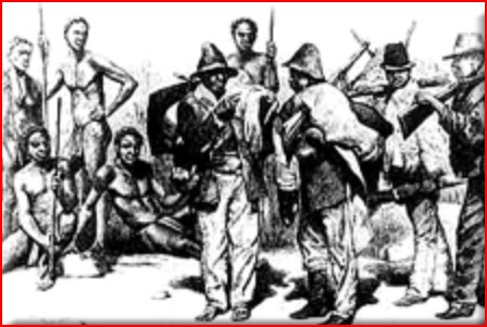
In the course of the 18th century, new communities defined by race, culture, religion and differential access to land and power began to emerge; they became tied together through the spoken word. One of these communities was the 'Bastaards' which referred to offspring of liaisons between Europeans, slaves and Khoikhoi. The term was also used to refer to subordinate Blacks who could speak Dutch, ride and shoot.
On White owned farms, Bastaards or Basters, did more skilled jobs such as transport riders and craftsmen. They took these skills with them later into the interior. The term 'Bastaards' originally denoted people with a greater “civilisation” and attachment to Christianity than the Khoikhoi or slaves.
In the second half of the 18th century, small Baster communities formed in the fringe areas of the northwest and the eastern frontier – Colesberg, Hantam, Roggeveld and Namaqualand. They could speak Afrikaans, had European names and their children were baptised in the church. They were even called up to do commando service. Notwithstanding these facts, they were increasingly being squeezed out from the land they held and they rarely succeeded in winning land claims as burghers invariably had the stronger claim, and better access to the field cornets who reported on any such claims. Basters and other people of mixed race moved first to the outer limits of the colony and then beyond its borders.
The Griquas could trace their forefathers to two clans, the Koks and Barendse, the first made up mainly of Khoikhoi and the second of mixed European descent.
A freed slave, Adam Kok, who managed to obtain burgher rights and a farm near the present Piketberg, founded the most vigorous mixed community. According to one tradition, Adam Kok married the daughter of the chief of a Khoikhoi clan, the Chariguriqua, during the 1750’s. He attracted a following as he moved up from Piketberg to Little Namaqualand and by the 1790’s Cornelius Kok, Adams’ son moved out of the colony to the Orange River and then eastwards along the bank to what is now known as Griqualand West. Cornelius had gathered with him a large number of Basters, some Khoikhoi and escaped slaves.
The two groups, under their respective leaders Cornelius and the brothers Barend and Nicolaas Barends roamed the area around the Orange River until 1804 when they were persuaded by two missionaries from the London Missionary Society to settle down with their followers north of the Orange River.
On the insistence of the missionary John Campbell, they came up with the name Griqua. They established a basic system of government based on leaders known as kaptyns and magistrates drawn from the leading families. Prominent families included were the Kok and Barends families, and the Waterboer family complex.
These families maintained stability by taking on a life of raiding and establishing trade links with their neighbours. It was alleged that Andries Waterboer had no White parentage but was a dependent of Adam Kok. Later, he allied himself to the church, acting as an interpreter and rose to influence after 1820 when he was appointed kaptyn. The Griquas attempted to achieve a greater measure of political autonomy by inviting the missionaries to join them.
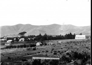
Later, the Griquas founded a settlement called Klaarwater, later known as Griquatown. The Griqua communities were constantly bedevilled with internal divisions and environmental uncertainty. One of the greatest causes of tension was between wanting to be within the colonial fold with its security and economic opportunities versus wanting to maintain independence. The missionaries wanted to Christianise the Griqua which would basically transform them into a settled agricultural and pastoral group. By drawing up a constitution, the kaptyns lost much of their power. Even though this created tension, it accorded the Griqua a degree of respectability while the missionaries offered some protection.
Poor relations between Waterboer and the Kok and Barends family complex caused Adam Kok II and Barend Barends to move away from Griquatown with their followers to Campbell and Danielskuil, respectively. Later Barends moved to Boetsap and the Koks to Philippolis. This made Andries Waterboer the dominant Griqua in Griquatown itself and the protégé of the missionaries.
The Griquas were the first people from the Cape to settle in the Transorangia area, beyond the Orange River. Some Griqua raided the Tlhaping, a Tswana speaking community, while others obtained cattle from them which was used to trade with the Cape farmers for firearms, horses and wagons,. The Griqua also acted as middlemen in a lucrative ivory trade between the Tswana and the colony, while others hunted ivory for themselves.
The Boers and Griqualand West
The Boers arrived in the area of Griquatown after Natal was taken over by the British. They acquired land from the Griqua, buying it in exchange for horses, liquor, firearms and ammunition. Trouble started when Kok arrested a Boer accused of ill-treating his people, and the trekker community tried to take over his entire territory. A British force stationed at Colesberg, quickly crossed the Orange River and defeated the settlers at Zwartkoppies.
Maitland, who was Governor at the time, decided to put an end to the territorial ambitions of the Boers by inventing a complicated system of land tenure whereby each chief’s land would be divided into two parts: one to be occupied by the chief and his people, and the other by the Boers who would pay rent to the chief and the Cape government.
Kok quickly agreed to this plan as it ensured that all regions south of the Riet River would remain inalienable Griqua property, while the area north of the river, although remaining under his control, would be leased by the Boers who were British subjects. In 1845, Maitland appointed a British Resident to Transorangia to oversee the implementation of this system, a job which Major Douglas Warden took over.
Maitland’s time as Governor came to an end in 1847 and was replaced by Sir Henry Pottinger, who was then soon replaced by Sir Henry George Wakelyn Smith. Smith rebuked Maitland’s system of land tenure and declared that all rent from White tenant farmers on Griqua land north of the Riet River would divert to the Crown. In addition, Whites would be allowed to obtain farms to the south of the river in an area, in terms of Maitland’s system, that could never be settled by Whites. Smith suitably humbled Adam Kok into acceptance of these terms.
By 1861, the Griquas, tired of the constant friction with their Dutch neighbours in the Orange Free State, sold them their lands, before settling in the territory of Griqualand East. In 1867, the discovery of diamonds near Hopetown brought about enormous changes in the social and economic make-up of the region. Overnight the area became flooded with fortune-seekers from Europe, North America and Australia. The ownership of this area became the subject of conflicting claims from the Khoikhoi, Tswana and Dutch groups.In March 1871, the diamond field claims were resolved in favour of the Khoikhoi leader Nicolaas Waterboer, who immediately petitioned the British for the annexation of his lands to the Cape Colony, for security reasons. As a result, on 27 October 1871 the diamond fields were proclaimed a British territory under the name of Griqualand West.
The Griquas derived no benefit from this; they were merely pawns in the hands of the Imperial authorities who were trying to acquire control over the mineral rich lands. In November 1876, Lieutenant- Governor Lanyon cleverly embarked on a surveying process with the intention of confining indigenous Black people to strategically placed rural locations which comprised about ten percent of the original Griqualand. The divisions of Barkley West, Hay, Herbert and Kimberley were probably proclaimed at about the same time.
However, the Cape Government, faced with the objections of both European settlers and indigenous residents, refused to incorporate the territory, and in 1873 Griqualand West was proclaimed a separate Crown Colony with its capital at Kimberley.
In 1876, Chief Waterboer, in whose name the diamond fields had been annexed, was arrested and imprisoned when he tried to free some of his followers from a prison work gang. On 5 August 1879, the Cape Parliament passed a Bill of Annexation, which was only implemented on 18 October 1880 (SESA 1972). A census taken in Griqualand West in 1877 revealed that the province had a total of 44,877 residents, of whom 12,374 were of European descent.
Griqualand East
In 1860, Adam Kok III trekked from the vicinity of Philippolis, where they had lost their lands to the emigrant Boers, to find a new home. They arrived in 1862 in the territory known as No Man’s Land, between the Cape and Natal. They lived in a laager for some ten years before founding their town of Kokstad.
Insecure and distrustful, in 1869 Adam Kok requested that the territory of Griqualand East be annexed by the British, with the specific stipulation that it should not be brought under the direct rule of Natal even though he was granted full title to the land and total autonomy of government. Accordingly Griqualand was taken over in 1874, and although the Act of Annexation was passed by the Cape Parliament in 1877, it was not promulgated until 17 September 1879. The territory was initially divided into four magisterial districts centred at Matatiele, Mount Frere, Umzimkulu and Kokstad, later renamed Mount Currie.
Throughout the 1870s, Griqualand East, and its surrounding territories, were the object of competing tribal interests and complex political alliances. As a result, the British found it difficult to implement effective colonial rule over the region until the remainder of Pondoland was also brought under their control. The lands of the Xesibe, centred at Mount Ayliff, were brought under their administration in 1878, but were not annexed to the Cape Colony until 25 October 1886.
In 1886, a small pocket of land called the Rode Valley was purchased from the Mpondo chief Umquikela, and was added to Mount Ayliff by Act No 45 of 1887, which was confirmed on 15 September 1888. The annexation of Pondoland to the Cape was completed under Act No 5 of 1894, provisions of which also ceded a portion of western Pondoland to Griqualand East. As a result of this transfer the divisions of Mount Fletcher, Qumbu, Tsolo and Maclear were brought under its administration.
The Griquas soon became a minority in the area and soon began to sell their properties to both European settlers and Pondo farmers, who were beginning to prosper there. The census of 1891 indicated that Griqualand East had a population of 152 618 persons, of whom 9 071 were literate. By 1904, these figures had risen to 222 685 and 21 146 respectively.
By 1917, the surviving Griqua people, highly demoralized by their loss of independence, once more trekked to a site near Touws River in the Karoo but their attempt to find a new community failed and most returned to Kokstad.
We are still developing this section. We will soon be adding information on the English people in the Bloemfontein region. If you have a community story click on the contribute tab.